Jetpack.io
A Design Challenge Exercise
Design Challenge Prompt: We’re taking transportation to the future by creating jetpacks perfect for the daily commute. These jetpacks let you fly exactly how you imagined as a kid. We have a working prototype of the product, now we need a mobile app designed to control the user’s flight.
My Role
I personally did all of the background research, visual design and prototyping. This is an example of what I can do when given a few hours over a weekend to complete a prototype and a functional specification.
Design Challenge Requirements
Required Core Functionality
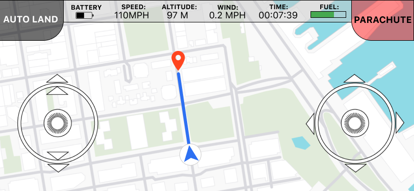
- Start/launch
- Navigation
- Fly up/down
- Fly left/right
- Fly left/right
- Turn left/right
- Emergency parachute
Technical Details
- App runs on iPhone only for now
- Maximum flight altitude: 100m
- Jetpack fuel lasts for 3h 30m
- Built in GPS
Problems to Solve
- Design an interface that is used to control the jetpack
- How do you fly?
- How do you take off and land?
- How do you know where you are?
- What other safety features could we have?
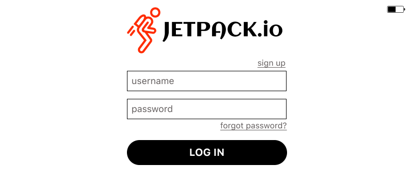
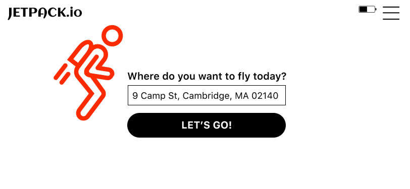
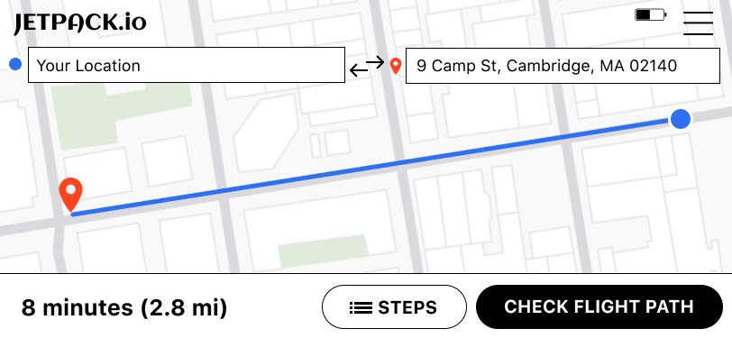
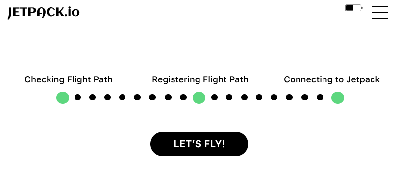
Clickable Figma Protoype
Note that on mobile, the embedded prototype (below) is too small to click on. Although I figured out how to make the Figma embed responsive, I have not yet figured out how to make the embed content larger at a mobile resolution, so use this direct prototype link instead.
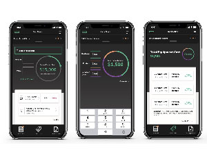
The Prototype
To operate the prototype, click anywhere on the iPhone screen. Blue "hotspots" will appear and show you where to click next.
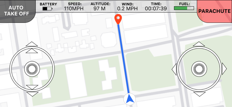
The prototype was designed in landscape mode to accomodate the jetpack controls, see the final screenshot.
Prototype Screenshots
Notes on Safety
Background
By its very nature, piloting a jetpack comes with a large amount of risk. However, to mitigate the risks to the pilot, the following were considered in the design of this app.
Safety Features
- The jetpack is not able to turn off when the user is up in the air. (the pilot cannot turn it off)
- The jetpack software keeps it from running out of fuel by mapping each trip before the pilot is up in the air and pre-estimating fuel consumption, plus adding a buffer.
- When fuel supplies are almost exhausted, it will emergency auto-land the user in a safe location (assuming there is one), if not, the jetpack will deploy the emergency parachute.
- If the user drops their phone while flying, the phone’s accelerometer will detect that the control system is in freefall and the jetpack will deploy the emergency parachute.
- I am making the assumption that the jetpack’s hardware was designed in such a way that the pilot will not be burned by the jetpack and will not need to wear any special clothing to avoid burns.
Auto Takeoff/Land
Concerns
I simply can’t imagine holding a phone while needing to look where you are flying when piloting a jetpack. I can’t see how this would be workable—or safe.
Because it is far too easy to drop one’s phone when piloting a jetpack, instead of creating an app for this project, I would recommend using a two handed joystick-like system that extends from the jetpack so that the user doesn’t need to hold a phone. A control panel display could be embedded into the “control arm” so the user could read the status of the jetpack’s fuel, speed, and other parameters. Although, I suppose you could also clamp a phone into one of the arms as well, marrying the two together.
All the working jetpack systems I have found use this sort of design:
All of that said, I suspended disbelief and designed an app that can control a jetpack that met the required criteria. This was a fun app to design and I appreciate the challenge.
No Fly Zones and Airmap Integration
Drone Flight
In order to gather some information on what considerations would be appropriate for jetpack flights, I did some research on drones.
You need three things to fly a drone:
- Good weather (is weather suitable for takeoff?)
- An appropriate takeoff location
- Need to know where no fly zones are located
AirMap
It's legal to fly a drone within 5 miles of an airport, but you have to notify the airport or local air traffic control in case they detect it on their radar. An app/service called AirMap does this online, using a system that the company is building in cooperation with the FAA. The system is being expanded to cover over 500 airports this year. This same system also keeps an eye on local air traffic, warning you if any manned aircraft are flying nearby. According to the research I did, many other drone-flying apps source their no-fly-zone maps from AirMap.
AirMap also provides a Digital Notice and Awareness System. This system lets you push a button to notify nearby airports that you are flying a drone. I thought the same sort of flight path information would need to be filed for jetpack flights. My app assumes that airmap features can be licenced and that they have been integrated into Jetpack.io.